


View forecast
Alt St. Johann/Toggenburg at 2627 m 高度
Snow-Forecast.comによる発表: 1 pm (現地時間) / 16 Apr 2024
Now
Tue 16 | Wednesday 17 | Thursday 18 | Friday 19 | Saturday 20 | Sunday 21 | Monday 22 | ||||||||||||||
after- noon | night | morn- ing | after- noon | night | morn- ing | after- noon | night | morn- ing | after- noon | night | morn- ing | after- noon | night | morn- ing | after- noon | night | morn- ing | after- noon | night | |
小雪 | 少量の雪 | 少量の雪 | 少量の雪 | 少量の雪 | 少量の雪 | 小雪 | 小雪 | 曇り | 小雪 | 豪雪 | 小雪 | 小雪 | 豪雪 | にわか雪 | にわか雪 | 小雪 | にわか雪 | 晴れる | 曇り | |
km/h | ||||||||||||||||||||
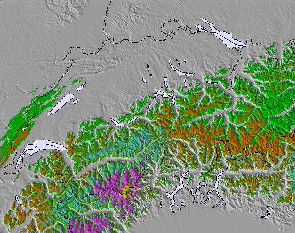
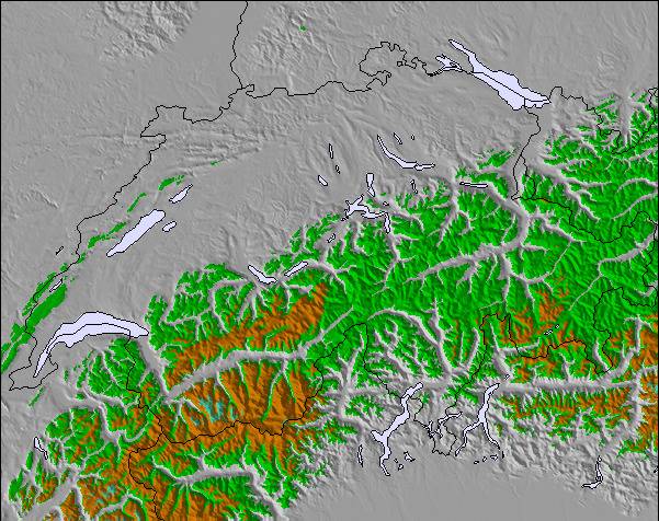
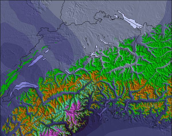
Snow map |  |  |  |  |  |  |  | |||||||||||||
cm | 2.0 | 9 | 6 | 8 | 10 | 5 | 3 | 2.0 | — | — | 17 | 2.0 | 3 | 15 | — | — | 3 | — | — | — |
mm | — | — | — | — | — | — | — | — | — | — | — | — | — | — | — | — | — | — | — | — |
max°C | -9 | -10 | -11 | -11 | -11 | -12 | -11 | -10 | -10 | -9 | -9 | -11 | -10 | -10 | -13 | -11 | -11 | -12 | -10 | -8 |
min°C | -10 | -10 | -11 | -11 | -11 | -12 | -11 | -11 | -10 | -10 | -11 | -11 | -10 | -12 | -13 | -12 | -12 | -12 | -11 | -9 |
chill°C | -21 | -20 | -21 | -20 | -18 | -19 | -18 | -19 | -16 | -20 | -21 | -21 | -18 | -17 | -19 | -20 | -19 | -20 | -18 | -13 |
湿度の高い% | 95 | 97 | 97 | 92 | 97 | 97 | 93 | 77 | 45 | 95 | 96 | 96 | 97 | 98 | 62 | 77 | 94 | 66 | 57 | 38 |
凍結高度 (m) | 1350 | 1100 | 1050 | 1050 | 950 | 950 | 1050 | 800 | 1050 | 1100 | 1150 | 1050 | 1200 | 850 | 800 | 1100 | 850 | 850 | 1100 | 950 |
— | — | 6:30 | — | — | 6:28 | — | — | 6:26 | — | — | 6:24 | — | — | 6:22 | — | — | 6:20 | — | — | |
— | 8:13 | — | — | 8:14 | — | — | 8:15 | — | — | 8:16 | — | — | 8:19 | — | — | 8:20 | — | — | 8:21 | |
翌 0-3 日の天気概要:
豪雪、最大 水曜日の午後の間. 気温は氷点下になるでしょう (最大 -9°C 火曜日の午後に, 最小 -12°C 木曜日の朝に). 風が弱くなる (強風 西から 火曜日の午後に, そよ風 北北西から 木曜日の夜までに).
翌 4-6 日の天気概要:
豪雪、最大 土曜日の夜間. 気温は氷点下になるでしょう (最大 -9°C 金曜日の午後に, 最小 -13°C 日曜日の朝に). 風が弱くなる (ほぼ強風 西から 金曜日の夜に, そよ風 北から 土曜日の夜までに).
Popular Alt St. Johann/Toggenburg Pages
雪レーダー
レポートを提出最新の雪レポート Alt St. Johann/Toggenburg:
31 km 遠い Alt St. Johann/Toggenburg から
6 hour 前
Light rain showers reported from Feldkirch at 440 metres elevation 9 kms WSW of Laternser Tal but it is forecast cold enough for snow at higher elevations in the ski area から Laternser Tal
49 km 遠い Alt St. Johann/Toggenburg から
6 hour 前Rain reported from Alberschwende at 715 metres elevation 5 kms NW of Andelsbuch but it is forecast cold enough for snow at higher elevations in the ski area から Andelsbuch
47 km 遠い Alt St. Johann/Toggenburg から
7 hour 前Rain reported from Alberschwende at 715 metres elevation only 3 kms ENE of Alberschwende but it is forecast cold enough for snow at the ski area から Alberschwende
44 km 遠い Alt St. Johann/Toggenburg から
9 hour 前Light rain showers reported from Dornbirn at 410 metres elevation 5 kms WSW of Schwarzenberg/Bödele but it is forecast cold enough for snow at the ski area から Schwarzenberg/Bödele
Alt St. Johann/Toggenburg の雪の状態
| 雪上部の深さ | — |
|---|---|
| 雪下部の深さ | 226 cm |
| 新雪の深さ | 10 cm |
| 最後の降雪 | 15 Apr 2024 |
Switzerlandの他のリゾートの報告: 粉雪 (6) / 状態のよいゲレンデ (3)
Snow-Forecast Partner Offers
Show your business here
雪の履歴
April月3 週の平均:
1.2 | ブルバードパウダーの日 新雪、おおむね晴れ、微風 |
|---|---|
2.1 | パウダーの日 新雪、時々晴れ、風あり |
1.0 | ブルーバードの日 平均的な雪、おおむね晴れ、微風 |

Switzerlandの他のリゾートの報告: 粉雪 (6) / 状態のよいゲレンデ (3)
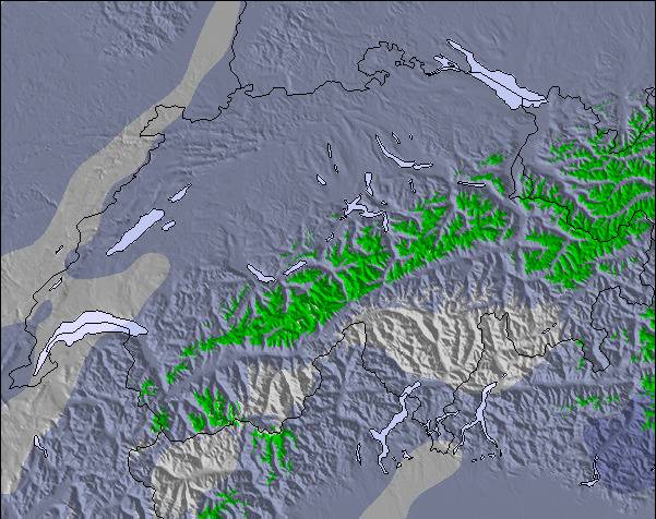
上記の表には Alt St. Johann/Toggenburg の2627 m の特定高度における天気予報が表示されています。高度な気候モデルによって、 Alt St. Johann/Toggenburg の山頂、中腹、麓にあるスキーステーションの雪予報を提供することができます。その他の高度の天気予報にアクセスするには、テーブルの上のタブナビゲーションをお使いください。より広範囲の天気予報には、 Switzerland の天気図をご覧ください。
ここをクリックし凍結高度や我々の気温の予測の仕方についてさらにご覧ください。
Alt St. Johann/Toggenburgのビジターによるレビュー
全体 3.4 基づいた 5 投票 および 1 レビュー
- スノーシュア
- 様々なゲレンデ
- 投票
- SwitzerlandのJacquesが記述:
Alt St. Johann/Toggenburg is a very cosy resort 1 hour drive from Zürich, 30mins away from St. Gallen and Vaduz. Beautiful alpine scenery with the 7 peaks visible from the valley, just behind the Santis. Not crowded. If you need skiing lessons, go visit Bruno and Jan in the Unterwasser skischool at sssuw.ch Very friendly and competent instructors! I love it. :)
Alt St. Johann/Toggenburgのビジターによるレビュー
SwitzerlandのJacquesが記述:
Alt St. Johann/Toggenburg is a very cosy resort 1 hour drive from Zürich, 30mins away from St. Gallen and Vaduz. Beautiful alpine scenery with the 7 peaks visible from the valley, just behind the Santis. Not crowded.
If you need skiing lessons, go visit Bruno and Jan in the Unterwasser skischool at sssuw.ch Very friendly and competent instructors!
I love it. :)
ご自身のウェブサイトに無料で利用できるSnow-Forecast.天気ウィジェット
下記の Alt St. Johann/Toggenburgスキー天気ウィジェットを使って、無料で外部のウェブサイトに組み込むことができます。これによりAlt St. Johann/Toggenburg の雪の予報と現在の気象条件の毎日の概況が分かります。フィード設定のページにアクセスし、簡単な3つのステップを踏むだけでカスタムhtmlコードスニペットを取得することができ、ご自身のサイトに貼り付けていただけます。ご自身のウェブサイトに合わせて、雪予報の高度(山の頂上、中腹、ふもとのリフト)やメートル法/ポンド・ヤード法を選ぶことができます。 クリックしてコードを取得
Alt St. Johann/Toggenburg の詳細な降雪予報を表示:
snow-forecast.com

 Nearest